

It matters because without this kind of detailed, place-based analysis, adaptation planning and risk management become guesswork. Cities might invest millions in flood protection for one area while leaving more vulnerable communities exposed. Or they might overlook critical infrastructure dependencies that turn a localised hazard into a city-wide crisis. Our tools help decision-makers make evidence-based choices about
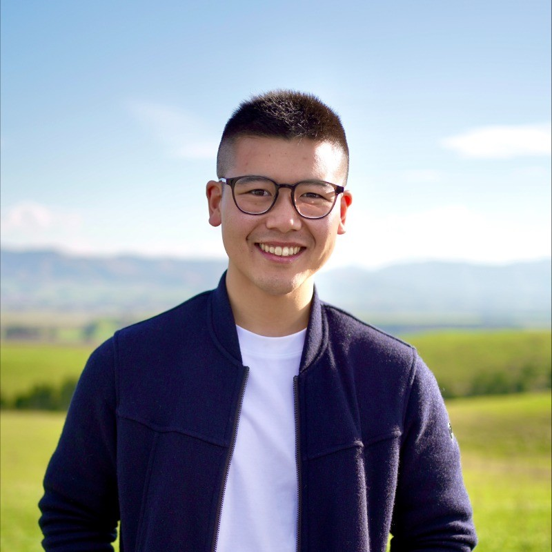
Just a few years ago, Mitchell Anderson was deep in his PhD research at UC, exploring how floods, earthquakes and other hazards ripple through critical infrastructure. Today, he’s CEO of Urban Intelligence®, a company turning complex climate data into practical tools that help cities, councils, and organisations make smarter, more resilient decisions.
You've gone from student to CEO in a few short years — what has that journey been like?
It’s funny, the job title doesn’t mean much in the early days when you’re the CEO of a team of two.. But fast forward five years, and I get the daunting privilege of serving a team of circa 30, and growing, across NZ and abroad. Needless to say, the role looks very different these days. You never really stop being a student, though, whether it's continued research in the climate risk and adaptation space or the continued learning of what is required to build and grow a business internationally.
I love the challenge of it all. I was 21 when Tom Logan and I founded Urban Intelligence®, and I somehow convinced myself that building a company from scratch, whilst simultaneously finishing a PhD, was a good idea. Looking back, I'm not sure I'd recommend it, but it's taught me an enormous amount.
During my PhD, I was focused on understanding how climate risks compound through infrastructure networks — how a flood doesn't just damage roads, but can cascade through power, water, and access to essential services. Throughout this time, and a short stint in the industry before hand, it became hugely apparent the gap between research and practice. Our cities, businesses, and other organisations make trillions of dollars worth of decisions related to risk, yet still use very manual and outdated techniques.
The first three years were intense — leading and building our team, product, and systems from scratch whilst trying to finish my thesis. It's been challenging, occasionally overwhelming, but incredibly rewarding. Going from writing academic papers to pitching to city councils and seeing our tools actually inform real decisions has been transformative. I've made plenty of mistakes along the way, and I'm still learning what works and what doesn't. I'm incredibly grateful to the Urban Intelligence® team for both leaning into the challenges at hand and also providing me the opportunity to hone my skills in the role.
For those who haven't heard of Urban Intelligence®, how would you describe what the company does and why it matters?
Urban Intelligence® ensures our cities, businesses, and communities make timely and informed decisions around natural hazard risk. In practice, this looks like a set of analytical tools for asset managers, land use planners, emergency managers, and others to (1) better understand the risks they face from flooding, fire, earthquakes, etc., and (2) make well-timed and informed decisions about how best to manage those risks. Our flagship product, Resilience Explorer®, helps cities understand their climate risks in spatial detail, not just "where might flood," but "who will be affected, which services will be disrupted, and what are the cascading consequences?". Think Sim-City, but in real life.

where to invest, who needs support, and how to build genuine resilience. It matters because without this kind of detailed, place-based analysis, adaptation planning and risk management become guesswork. Cities might invest millions in flood protection for one area while leaving more vulnerable communities exposed. Or they might overlook critical infrastructure dependencies that turn a localised hazard into a city-wide crisis. Our tools help decision-makers make evidence-based choices about where to invest, who needs support, and how to build genuine resilience.
Managing risk isn't a new or novel concept. But with the frequency and intensity of these 'unprecedented' extreme events increasing, simply transferring risk through insurance isn't as viable an option as it once was. What sets Urban Intelligence apart is our focus on accessibility and actionability - making sure that everyone from Joe Bloggs to the CFO of your local council understands what tangible actions they can take to reduce the impact from the next big one. While traditional risk models exist in academic institutions and large consultancies, they're often expensive, slow to deploy, and require specialist expertise to interpret. We've built a software platform that puts sophisticated spatial risk analysis directly into the hands of the people who need it, making complex modelling accessible, affordable, and immediately usable for decision-making. It's the difference between commissioning a six-month consulting study and having interactive risk insights at your fingertips within minutes.
What's been the most rewarding — and the most challenging — aspect of leading a start-up in the climate resilience space?
The most rewarding part is absolutely seeing our work make a real difference. The NHS Property Services in the UK uses our platform to assess flood and heat risk across their entire estate, helping them prioritise which healthcare facilities need urgent adaptation measures, ensuring patients and staff remain safe during extreme events. In Hawke's Bay, growers have used our tools to build contingency plans around flood and drought scenarios, protecting their operations and livelihoods in a region that's seen devastating impacts from Cyclone Gabrielle. We've worked with airports to model future flood levels, leading them to raise floor levels in new buildings, a decision that will protect critical infrastructure for decades. And councils are using Resilience Explorer® to empower their communities, creating transparent roadmaps for adaptation that show residents exactly what risks exist in their neighbourhoods and what interventions are planned.
The challenge is making sophisticated risk modelling genuinely accessible, we've had to completely rebuild our interface three times to get it right. Early versions were clunky and overcomplicated. Now, a council planner with no engineering background can run a scenario in under 5 minutes. That simplicity took enormous complexity behind the scenes.
The other reality is that we're often asking organisations to confront uncomfortable truths about their exposure, which can meet institutional resistance. It's one thing to acknowledge climate risk in principle; it's another to see your critical assets mapped in red.
Can you give an example of how Resilience Explorer® has already made a tangible difference in decision-making or community planning?
We’ve worked really hard in New Zealand to ensure, as a country, we are accelerating climate adaptation, and are now at the point where our tools are being used to support decisions across over a third of the population. In regards to tangible examples, several really stand out, I'll highlight a couple that show the breadth of application.
Hawke's Bay Airport became the first airport in Aotearoa to implement Resilience Explorer®, and they've recently won the Sustainability Initiative of the Year award from the NZ Airports Association for their work. They're positioned just metres from the surrounding wetlands, serving 180,000 residents whilst facing escalating climate risks. Using the platform, they could see exactly how coastal flooding, rising groundwater, tsunami threats, and other hazards might affect their infrastructure across different timeframes and scenarios.
This detailed analysis has directly influenced critical infrastructure decisions. When constructing their new fire station, they raised the floor level by 1.2 metres to mitigate flooding risk. Plans for a tenanted aircraft hangar were relocated to areas with reduced groundwater risk, potentially preventing millions in future damage costs. Rather than applying broad assumptions across the entire airport campus, they can now target investments based on actual risk profiles.
Another great example is the Christchurch City Council (CCC), which provides services to over 400,000 people within its boundaries. CCC have been an outstanding partner and early adopter of the platform. Subsequently, this has been it rolled out to most major departments in the council and has been a pivotal part in the recently announced adaptation plan across part of Banks Peninsula where it has informed the type, location, and timing of over $100M in adaptation actions over the next few decades.
What's particularly rewarding about these partnerships is seeing how the platform enables different types of organisations, from airports, electricity networks, community housing providers, and councils, to make evidence-based decisions that genuinely protect their communities. That's what keeps us going.
Looking ahead, what's next for Urban Intelligence® and the Resilience Explorer® tool?
We're focused on three key areas. First, expanding our capability to model cascading and compound risks, how multiple hazards interact, how impacts ripple through interconnected systems (such as a power station becoming damaged, leading to telecommunications and wider network disruptions well beyond the initial hazard area). That's where some of the most impactful, yet least understood, risks lie.
Second, we're working on making our tools more accessible. Not every organisation has a team of technical experts, so we're developing ways to democratise access to sophisticated risk analysis, making it intuitive, visual, and actionable for diverse users.
Third, we're looking more deeply into the equity dimension. Climate impacts aren't evenly distributed, and adaptation planning needs to actively address that. We're developing new ways to visualise distributional justice, showing not just where risk is highest, but who bears the greatest burden and who has the least capacity to adapt. Our social researchers, including Dr Sarah Harrison and Dr Paula Blackett, bring essential perspectives to this work.
Ultimately, we want Resilience Explorer® to become the standard tool that helps cities worldwide plan adaptation that's not just effective, but equitable and just. I think it's fantastic that we can shed light on this kaupapa and the big challenges facing our communities. With the team we've built, spanning technical development, climate science, social research, and practical implementation, I believe we're well-positioned to make that happen. There's urgent work to be done, and we're committed to being part of the solution.
When reflecting on your time at UC, what memories or experiences stand out to you?
UC gave me the foundation and freedom to pursue this path. The Civil Engineering department encouraged us to tackle real-world problems, and the interdisciplinary environment, working across engineering, geography, and risk science, shaped how I think about complex systems.
What made UC exceptional was how it supported me to incubate, validate, and push these ideas forward. The Civil Systems and Risk Lab and the Cluster for Community and Urban Resilience (CURe) provided an environment where I could test unconventional approaches, combining engineering models with social vulnerability frameworks. But critically, UC backed me to present this work internationally, connecting with research collaborators across Europe, North America, and Asia-Pacific, and presenting at conferences globally. That exposure was invaluable. It forced me to refine my thinking, defend my methods against world-leading experts, and iterate the work until it was robust enough to commercialise.
Being in Ōtautahi Christchurch itself was significant. This is a city that lived through catastrophic seismic events and their cascading consequences, where the recovery process revealed hard truths about infrastructure interdependencies and community vulnerability. That context, even for those of us who came later, shaped the urgency and relevance of the research environment. You're studying systemic risk in a place that experienced it profoundly. UC didn't just give me technical skills; it gave me a global platform and a grounded perspective to develop ideas that now underpin Urban Intelligence.